

Services
CRIME NABI for Government
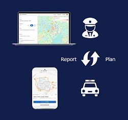
Crime prediction and public safety AI platform for governments and local governments
AI predicts crime risks for each region and enables next-generation public safety measures, such as optimizing patrol routes.
It maximizes public safety with limited security resources and helps prevent crime before it happens. In fact, police patrols using Crime Navi in a major Brazilian city have resulted in a 68.5% reduction in crime. Crime Navi will provide strong support for public safety measures, helping to create a safe and sustainable society.

Supporting crime prevention issues with a multi-product approach


Use Cases:
Brazil, Minas-Gerais, Belo Horizonte Municipal Police
“Innovation makes safety-related operations more effective."
By Mr.Fernando Motta, Director of Economic Development for the City of Belo Horizonte


Background
The Federal Republic of Brazil, State of Minas Gerais, Belo Horizonte City (hereinafter BH City), and the Municipal Police Force jointly verified the effectiveness of this system. In recent years, BH City has experienced a sharp increase in cable theft, which has become a social problem affecting traffic signal malfunctions and disrupting power supply to factories and hospitals. Therefore, this verification focused on cable theft. With the full cooperation of BH City and the Municipal Police Corps, we verified the effectiveness of the patrol support services provided by “CRIME NABI”.
Solution Overview
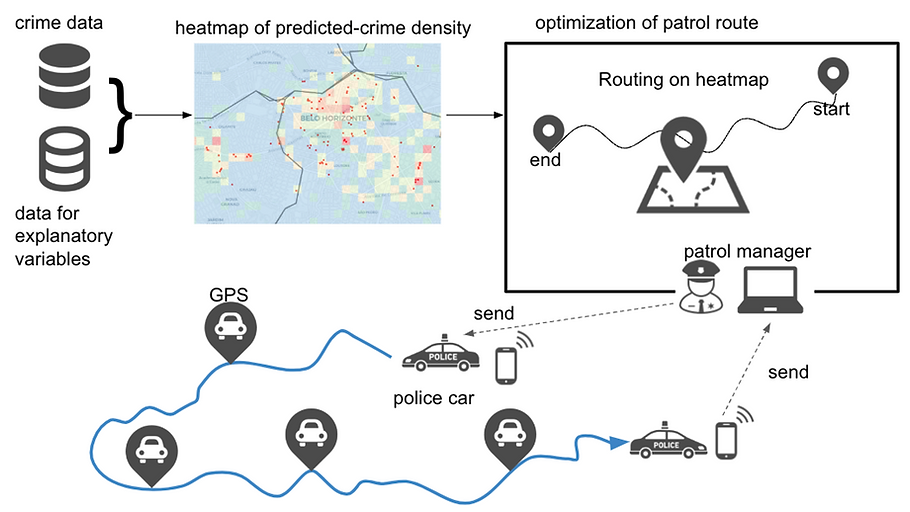
Figure: The Belo Horizonte Municipal Police Department utilized the patrol support solution “CRIME NABI MOBILE / WEB” to intensify patrols targeting cable theft. As a result, they achieved a 69% reduction in cable theft incidents.
The Belo Horizonte Municipal Police Department implemented the patrol support solution “CRIME NABI MOBILE / WEB”.
For patrol operations managers, we provided the web application “CRIME NABI WEB” to support patrol instruction creation and patrol management. This web application collects historical crime, urban, geographic, and satellite imagery data to predict crime, enabling real-time formulation of optimal patrol routes that maximize security effectiveness. Previously, creating patrol instructions required hiring specialists and manually using multiple applications, resulting in high time costs and monthly updates only. This system enabled more frequent updates.
For patrol car crews conducting patrols, the mobile app “CRIME NABI MOBILE” was provided. It includes a patrol navigation function that receives instructions and provides route guidance, along with automatic recording of GPS-based electronic daily reports.
From an operational management perspective, transitioning from paper-based management to efficient cloud-based management utilizing tamper-proof GPS data has significantly reduced human and time costs. Integration between mobile and web platforms enables real-time visualization of security status, patrol management, and analysis/evaluation of performance, leading to improved management effectiveness for officers.


Figure1 : Crime Nabi Mobile/Web Application
Implementation Effect
The effectiveness of the Crime Nabi crime prediction system, implemented in collaboration with the Belo Horizonte Municipal Police in Minas Gerais, Brazil, was verified. During the two-month period of Crime Nabi utilization, the number of cable theft incidents across the city decreased to 171 cases, a 69% reduction compared to the 543 cases recorded in the two months prior to its implementation, confirming the system's effectiveness.
Furthermore, during the verification period, GPS data from patrols was recorded via a mobile application, enabling a more detailed analysis of the system's effectiveness. Below is an example of the crime prevention effect of patrols utilizing crime prediction in a specific district. The left side shows the crime occurrence map for the exact same area before using Crime Nabi, and the right side shows it during Crime Nabi use. Green indicates clusters of crime locations, and blue indicates patrol GPS information. Notably, in the area where patrols utilized crime prediction, crime decreased during the PoC period compared to before the PoC period.

Figure 2: Reduction in Cable Theft Incidents Following Crime Nabi Implementation (Comparison Before and After Implementation)
A citywide comparison between areas utilizing Crime Nabi and those not utilizing it revealed that areas employing Crime Nabi achieved approximately twice the crime deterrence effect compared to non-utilizing areas, confirming the system's effectiveness.
Voices of the officers on the scene
■Comment from Fernando Motta, Director of Economic Development for the City of Belo Horizonte
“The insights brought by innovation make safety operations more effective, and the results lead to cost savings and quality improvements for the city and its citizens. It enables better services and data-driven decision-making.” Click here for Press release from the City of Belo Horizonte
Police officers who actually conducted patrols on the ground reported: “A cable theft occurred right after we finished patrolling,” and “The patrol routes indicated by CRIME NABI definitely guided us to areas perceived as dangerous, heightening our alertness.”
Details of these results were also presented at the 17th Annual Brazilian Public Security Forum held in Belém, Pará State, Brazil, in collaboration with Belo Horizonte City. The forum was attended by public security officials from all Brazilian states and generated significant interest, particularly among police personnel.